MatrixSpace Newsroom
Press Releases
Portable, Multi-Sensor Detection for Real Drone Threats
Unlocks Decisive Drone Detection for Evolving Airspace

Winning solution demonstrates scalable, cost-effective sensor technology to strengthen the Nation’s layered defense and advance DOW strategic priorities
Lowest power, portable and affordable low-airspace drone detection
MatrixSpace Named Active Sensor Winner in U.S. Army Operation Flytrap 4.5, xTechCounter Strike Competition
MatrixSpace, a leader in portable AI-enhanced radar counter drone sensing technology, announces the completion of its $20 million Series B funding round.

Showcases strong technology partnerships with Kongsberg Geospatial and MatrixSpace, positioning Volatus as the integrator of a proven ecosystem. Strengthens Volatus’ competitive position as one of the few Canadian operators authorized at this advanced level. Enhances Volatus’ commercialized drone-in-a-box and advanced BVLOS applications by introducing a scalable light weight detect and avoid systems. Expands Volatus’ BVLOS portfolio into higher-value missions unlocks recurring revenue opportunities in drone-in-a-box, logistics, and enterprise monitoring.

Integration delivers AI-enabled radar situational awareness to DroneSense Remote software, for scalable, real-time drone operations

Aerospace technology provider Sagetech Avionics has selected AI sensing system innovator MatrixSpace to support its advanced airspace solutions. Sagetech Avionics empowers safe flight in crewed and uncrewed aircraft with certifiable situational awareness solutions, serving military, public and commercial organizations.
MatrixSpace integrates Dell NativeEdge to enhance real-time AI, strengthen public safety programs, and support next-generation smart city initiatives

Palm Springs Police Department (PSPD) has expanded its Drone as First Responder (DFR) program, establishing the largest first responder agency coverage area (37 square miles) monitored by radar sensors instead of humans in the United States. The PSPD’s program expansion was made possible with multiple remote drone launch points across Palm Springs utilizing MatrixSpace’s low airspace awareness technology. This innovation has also supported the city’s application for a FAA No Visual Observer flight operations waiver to ensure the safe separation and avoidance of both general aviation and commercial aircraft.

HSWERX, the Department of Homeland Security’s (DHS) innovation hub, awarded MatrixSpace Radar to provide advanced air detection to support uncrewed aircraft systems (UAS) operations. The technology has potential applications across a variety of mission environments, including the DHS Customs and Border Protection (CBP) agency.

Advexure, one of the US's largest dealers, distributors and systems integrators for uncrewed drone systems and technology solutions, has partnered with MatrixSpace to enhance its customers' drone operations and perimeter security solutions.

Skyway provides essential services to airline operators, eVTOL manufacturers, and commercial developers, including vertiport airspace and airfield management. By teaming up with MatrixSpace, Skyway will expand its current integration and leverage MatrixSpace Radar’s advanced AI-enabled sensing technology to enhance situational awareness in Skyway’s upcoming deployments.

Reflecting the growing momentum of its advanced AI-sensing radar solutions, MatrixSpace has appointed Wes Boyd as Vice President and General Manager of Radar Systems.

Campbell Police Department (CPD) is making significant strides in its Drone as First Responder (DFR) program, making it the first U.S. law enforcement agency to secure a camera and radar-based Beyond Visual Line of Sight (BVLOS) waiver for DFR.

Expanding its pioneering Drone as First Responder (DFR) program, Campbell Police Department (CPD) is the first in California, using optical and radar sensors, to incorporate radar in a Part 91.113(b) waiver request to conduct single-person operations, which requires only one operator for flight operations.

FAA Waiver Allows Campbell PD to Deploy DedroneBeyond for Drone-Agnostic Day and Night DFR Operations Without a Visual Observer

ARES Security and MatrixSpace announce a technology partnership that combines the AI collaborative sensing capability of MatrixSpace Radar™ with ARES Security’s AVERT Mission Planning and Operations (MPO) software for autonomous systems.

Legionnaire International has been selected for a $3.19M AFWERX Challenge SBIR Commercial Services Offering contract to design and deliver a new potentially podded refueling boom for tactical aircraft.

MatrixSpace has been selected for a $1.9M AFWERX Tactical Funding Increase (TACFI) Phase II Sequential contract to develop a distributed dual-mode mesh radar for base defense, based on the MatrixSpace Radar hardware platform.
MatrixSpace has been selected by AFWERX for a $1.25M Direct-to-Phase II SBIR to develop a prototype low SWaP-C multi-function, multi-band antenna payload, based on the MatrixSpace Radar hardware platform.

INVOLI, a leading provider of cooperative air traffic surveillance solutions, is thrilled to announce its partnership with MatrixSpace, an expert in non-cooperative air traffic detection. This partnership marks a significant milestone in aviation safety and surveillance technology.

MatrixSpace Radar is now shipping to commercial and public organizations in the United States and approved international countries. The award-winning product’s commercial delivery follows its recent Federal Communications Commission authorization.

MatrixSpace and INVOLI have co-led the first F3623-23 Standard Specification for Surveillance Supplementary Data Service Provider (SDSP) published by ASTM International.

MatrixSpace Radar has been thoroughly tested to perform within the FCC’s emissions and frequencies specifications and can now be sold to commercial and public organizations in the United States.

Retired US Army, Navy and Homeland Security Leaders Vice Admiral Rich Brown, Brigadier General Peter L. Jones and Tom Bush Join Advisory Board.

MatrixSpace announces the addition of Lieutenant General (retired) Michael Barbero to its advisory board, strengthening its engagement within the defense and commercial sector.

MatrixSpace, a leader in AI collaborative sensing solutions, announces $10M raised in Series A funding. This brings the company’s total funding to $20M since its first year of operation in 2020 and will enable it to accelerate technology advancements, customer adoption and revenue growth.

MatrixSpace announces the addition of Lieutenant General Glenn Spears, US Air Force (retired), and Brigadier General Robert Hipwell, Ph.D, US Army (retired), to its Advisory Board, strengthening its engagement with the defense sector.
Compact, high-performance radar enabling multiple industries to digitize the outdoors for new levels of awareness.

The Women and Drones Leaders’ Summit with Chief Revenue Officer, Lori DeMatteis

Learn about the latest developments in uncrewed and autonomous flight from a business, regulatory, city planning, and technology perspective.

Recently launched MatrixSpace announces the appointment of AI and machine learning expert Nihar Nanda PhD as Head of AI Products, responsible for AI product development.

Recently launched MatrixSpace announces the appointment of industry sales leader Lori DeMatteis as Chief Revenue Officer.

Addressing the next generation of AI-enabled sensing solutions, MatrixSpace announces completion of $10.1M in private investor funding with secured enterprise and government customers in place.
MatrixSpace in the News


MatrixSpace, a leader in portable AI-enabled radar for counter-UAS missions, is the winner in the U.S. Army’s xTechCounter Strike competition, part of Operation Flytrap 4.5. MatrixSpace was the only active sensing provider selected among 15 finalists, highlighting the company’s breakthrough capabilities in rapidly deployable airspace awareness. Operation Flytrap is the U.S. Army’s key initiative to accelerate innovative, scalable C-UAS technologies through live soldier experimentation, rapid acquisition pathways, and transition to operational units.

MatrixSpace has just done something many airspace awareness vendors promise, but rarely deliver. It turned radar from a point sensor into the centerpiece of a multi-sensor, AI-native system that scales from a single box on a tripod to a cloud-connected enterprise mesh. As the number of drone incursions, beyond visual line of sight (BVLOS) operations increase and complex urban events increase, that evolution matters. It gives operators a practical way to see, understand and act on everything moving in their low-altitude airspace, without forcing them to rip and replace the systems on which they already rely.

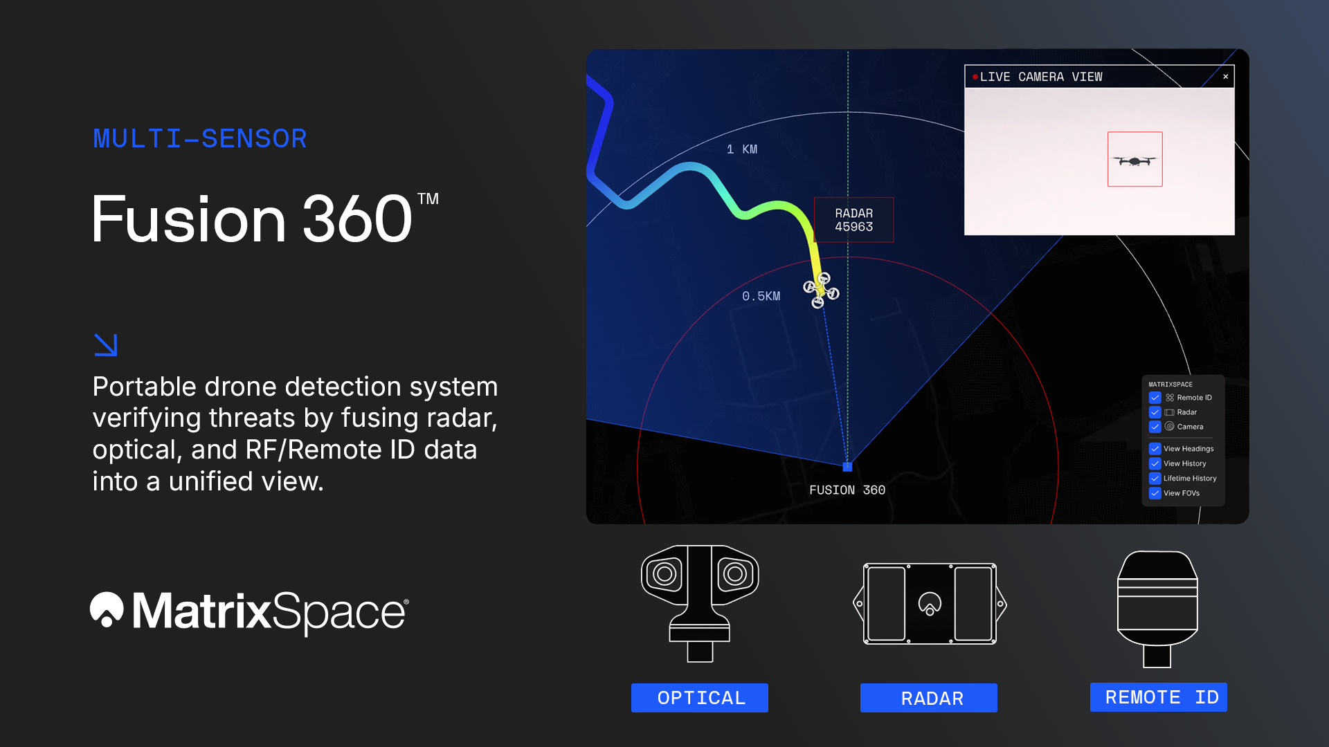
MatrixSpace is widening its portable drone detection portfolio with the launch of MatrixSpace Fusion 360. The system looks to fuse radar, optical, and RF/Remote ID sensor data into a unified view – the company describes it as its multi-sensor device.

Burlington, MA-based MatrixSpace has introduced the MatrixSpace Fusion 360, a new addition to its counter-drone portfolio integrating radar, optical, and RF/Remote ID sensors into a unified system for real-time airspace awareness. The new platform collates multisensor data at the point of detection, allowing operators to quickly verify and respond to aerial threats.

MatrixSpace extends its advanced, portable drone detection portfolio with the launch of the multi-sensor MatrixSpace Fusion 360, verifying threats by fusing radar, optical, and RF/Remote ID sensor data into a unified view. Fusion 360 delivers trusted counter-drone awareness by fusing radar, optical, and RF/Remote ID sensors into a single, authoritative airspace picture — so operators can confirm threats quickly and act with confidence.

“Built as a fusion-native system, Fusion 360 correlates sensor data at the point of detection and tracking, reducing false alarms while improving identification of small, low-flying, and evasive drones in complex environments such as public events, critical infrastructure, and operational theaters. It also distinguishes hostile “dark drones” from compliant or friendly aircraft, providing clear threat relevance instead of noise. The result: faster decisions, fewer distractions, and better protection.”

Fusion 360 delivers trusted counter-drone awareness by fusing radar, optical, and RF/Remote ID sensors into a single, authoritative airspace picture—so operators can confirm threats quickly and act with confidence.

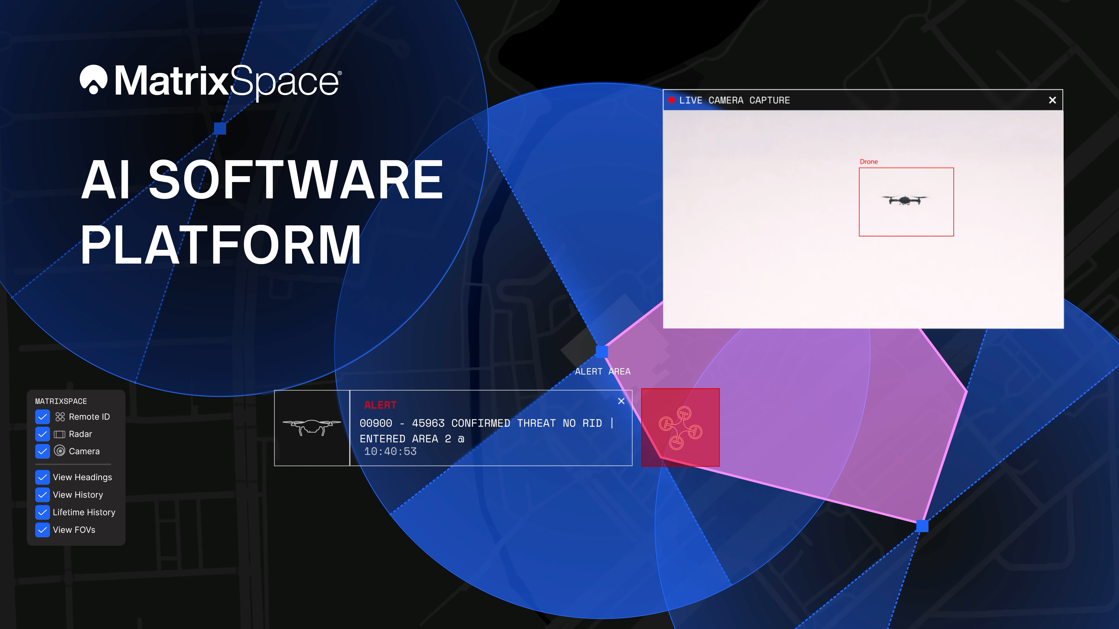
MatrixSpace, a Massachusetts-based developer of AI-enabled sensing and radar systems, has announced a major update to its edge-to-cloud MatrixSpace AI Software Platform. The platform now supports multi-sensor, multi-drone detection in real time for counter UAS applications. It enables threat assessment and early warning by detecting, tracking and identifying aerial activity, supporting on-site and remote operators to make split-second decisions regarding airspace activity. The platform is sensor agnostic and can be integrated into existing systems through open APIs.
Come Meet With Us

Videos
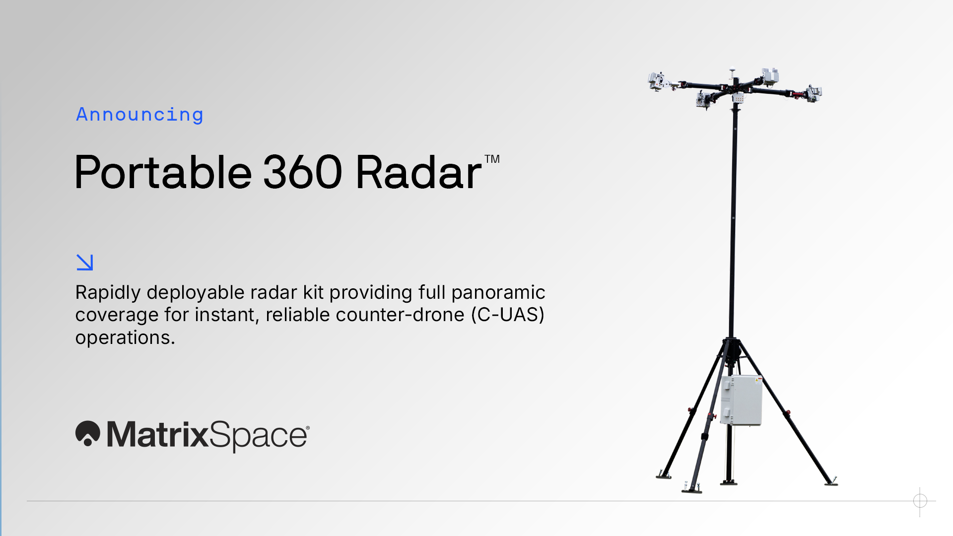
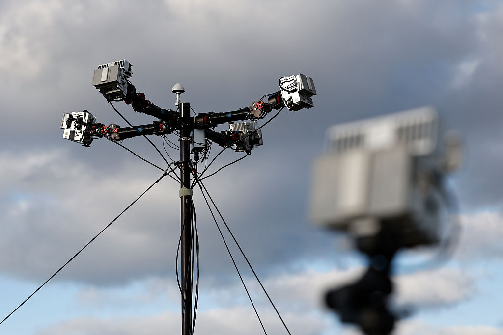
Rapid, resilient counter-drone detection anywhere. Introducing MatrixSpace Portable 360 Radar™: a fully transportable, ruggedized radar kit that sets up in minutes, operates with minimal power, and provides resilient panoramic coverage wherever you need it that easily scales to assure public safety.