The Latest Updates, Perspectives and Stories From MatrixSpace
.jpeg)
Observations from Project Flytrap 5.0
MatrixSpace demonstrated portable, resilient counter-drone capabilities at the U.S. Army’s Flytrap 5.0 exercise, integrating mobile radar and AI systems with Anduril’s battle command network. The deployment validated effective small-drone detection, operation in contested environments, rapid dismounted deployment, and interoperability through open architectures for modern battlefield airspace awareness.

Threat Truth or Dare: Layered Detection for Modern C-UAS
Rising drone threats are driving organizations to adopt systems that detect, track, and identify them. Effective defense requires layered, multi-sensor approaches, with radar as the backbone for real-time threat assessment.
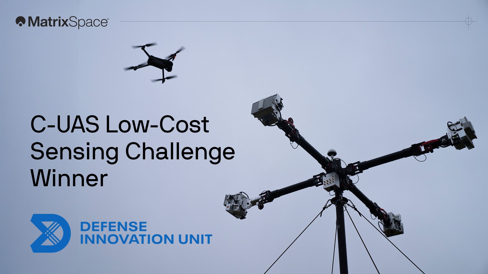
2 Major Military Competition Wins and Transforming Defense Technology
We're proud to have won both the DIU C-UAS Low-Cost Sensing challenge and the Army xTechCounter Strike competition. Innovation like ours is needed to modernize national security capabilities.
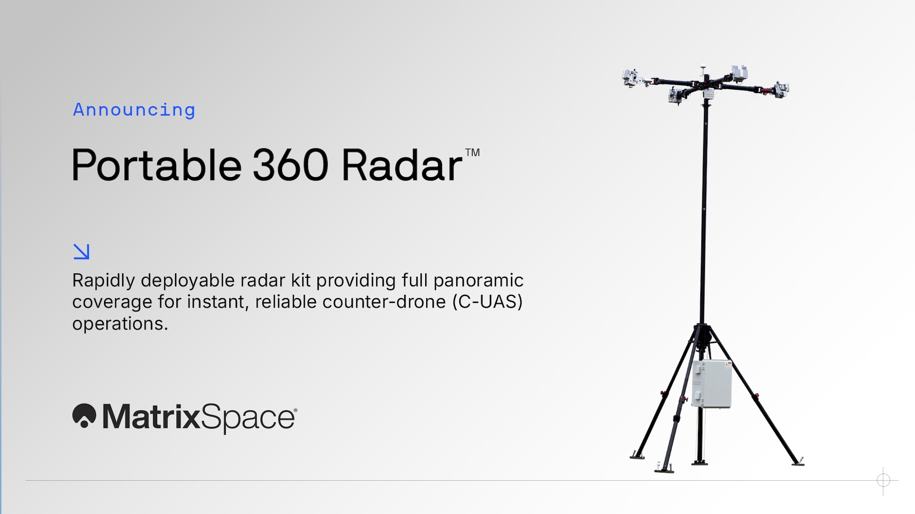
Introducing MatrixSpace Portable 360 Radar™: Rapid, Resilient Counter-Drone Detection Anywhere
Protecting airspace security for temporary operations—whether stadium events, public gatherings, expeditionary maneuvers, or sensitive activities in/near secure sites—has never been more urgent. Drone threats are increasing, and traditional radar systems simply aren’t built for the speed and flexibility these scenarios demand.

Open by Design: How Our Software Platform Enables Customer Ecosystems
Everything we build at MatrixSpace is designed for easy integration and extensibility. It allows us precise control our radar systems with precision, embed them with deep technology features, visualize data for users and orchestrate sensor interconnection. It also allows us to quickly integrate our systems with a broad ecosystem of other applications through open APIs.

The DIU C-UAS LCS Challenge: Winning the Drone War with Innovation
MatrixSpace was selected as one of 10 finalists for the DIU's Low-Cost Sensing challenge for counter drone detection, addressing the lack of affordable scalability in traditional defense sensor systems.

DroneSense & MatrixSpace: Situational Awareness to Unlock Critical Response
DroneSense customers can now seamlessly conduct remote operations with comprehensive airspace awareness in a common operating picture with the inclusion of MatrixSpace radar detection intelligence.

Radar, Aviation Radionavigation vs. Radiolocation—Why Your Use Case Matters
The usage of radar for guiding vehicles and protecting people/places is strictly regulated for safety and to ensure reliability across radio spectrums. Your use case dictates how to comply with rules for radionavigation and radiolocation.

8 Ways Combined Radar and Drone Solutions Can Improve Rail Safety and Security
Railyards and rail lines face significant challenges daily—from theft, vandalism, and costly derailments. Technology enables securing their perimeters more effectively while also improve asset inspection practices.
Latest News


MatrixSpace Brings Portable Counter-Drone Radar to Lithuanian Exercise
The xTechCounter Strike winner deploys portable AI-powered radar to strengthen low-altitude airspace awareness for M-SHORAD units in Pabradė. MatrixSpace is supporting the U.S. Army’s Flytrap 5.0 counter-drone exercise from May 1 through May 15, 2026. The Massachusetts-based company announced its participation on May 12. The deployment follows its xTechCounter Strike win during Flytrap 4.5 in November 2025.

MatrixSpace provides airspace awareness for Operation FlyTrap 5.0
MatrixSpace is supporting the FlyTrap 5.0 training exercise (May 1-15, 2026) with its sensor providing rapidly deployable airspace awareness after winning the xTechCounter Strike competition in Operation Flytrap 4.5 in November 2025. Project Flytrap 5.0 is a major U.S. Army-led counter-unmanned aircraft system (C-UAS) exercise taking place in Lithuania in May. “This initiative brings together US and UK forces to test and validate new, low-cost, and portable drone detection and defeat technologies, designed to counter rapidly evolving threats on the battlefield.” “The Maneuver Short-Range Air Defense (M-SHORAD), designated as the “SGT Stout,” is a U.S. Army system designed to protect maneuvering forces from unmanned aircraft systems (UAS), rotary-wing, and fixed-wing threats,” said the company. “But today’s fight is increasingly dominated by low-altitude, small UAS that are hard to detect and even harder to track. These threats operate in the clutter—RF-silent FPVs, loitering munitions, and pop-up drones that compress engagement timelines and often evade traditional sensors”.

MatrixSpace enhances airspace during Flytrap 5.0 exercise
MatrixSpace is providing enhanced airspace awareness during the U.S. Army-led Flytrap 5.0 counter-drone training exercise taking place May 1–15, 2026, in Lithuania. The company’s participation follows its success in the xTechCounter Strike competition during Operation Flytrap 4.5 in November 2025.

Five Good Questions: MatrixSpace
Matthew Kling, VP and General Manager of AI Systems at MatrixSpace, leading development of the AiCloud and AiEdge platforms, answers five very good questions form the executive editor of Inside Unmanned Systems.

Building the Full Stack for Counter UAS Technology, with Matt Kling
Matt Collins speaks with Matt Kling, VP and general manager of AI Systems at MatrixSpace. The two discuss how the Safer Skies Act has shaped demand for counter-UAS technology, why gaps still exist between what agencies need and what's being deployed, and how MatrixSpace is approaching the counter-UAS challenge as a radar-first, hardware-and-software hybrid company.