Press Releases


Veteran Counter Drone Leader John Knag Joins MatrixSpace
Burlington, MA (June 16, 2026) – With the rapid growth of the MatrixSpace business, John Knag joins as Vice President of Product.
An industry pioneer in C-UAS (counter drone) technology, John will accelerate MatrixSpace’s product roadmap and system integration with key industry players.
Quote from Greg Waters, CEO, MatrixSpace
“John brings a fantastic background as both an innovator and user of drone detection, public safety first-response (DFR), and C-UAS systems. As major governments and multinational corporations rapidly adopt counter drone capabilities as part of their business models, John’s talents will significantly accelerate the adoption of our platforms.”
Quote from John Knag, VP of Product, MatrixSpace
“The opportunity to innovate and meet a wide range of emerging customer requirements has never been greater, and MatrixSpace sits squarely at the front of this growth. The milestones already met by this team are impressive, and I look forward to continuing to advance capabilities and adoption for the evolving world of drone detection.”
John brings extensive counter drone experience, most recently building and leading the product and engineering team at Dedrone/Axon. Before that he led BAE Systems Electronic Warfare development group engaged in activities from mixed-signal IC design to all digital phased array systems and small form factor EW systems. He also founded a number of start-ups in these areas.
He began his career as an aerospace engineer, moving into the emerging drone space, with ground-breaking work at the Department of Energy and US Air Force on C-UAS applications.
He holds multiple patents in aircraft design, sensors, weather systems, electronic warfare, and C-UAS and holds Bachelor’s and Master’s degrees in Aeronautical and Astronautical Engineering from Stanford University.

MatrixSpace Leases 10,569 Square Feet of Office and R&D Space at 76 Blanchard Road in Burlington, Massachusetts
BURLINGTON, Mass. – March 31, 2026 – Cushman & Wakefield, a global real estate services firm, announced that MatrixSpace, a leader in portable AI-enabled radar for counter drone solutions, signed a lease for 10,569 square feet at 76 Blanchard Road in Burlington, Massachusetts.
MatrixSpace selected 76 Blanchard Road, owned and managed by Duffy Properties, to support its continued growth and operational expansion in Greater Boston. The new space will accommodate the company’s increasing AI/software development and engineering talent base.
The transaction underscores the continued strength of the Burlington market for growing technology and advanced manufacturing companies.
"Burlington continues to attract companies at the forefront of AI, robotics, and advanced hardware. MatrixSpace’s expansion at 76 Blanchard Road is another example of the innovation momentum building within this submarket," said Bob Duffy of Duffy Properties. "As a hands-on ownership group, we value working with companies pushing technological boundaries and remain committed to providing the flexibility and responsiveness fast-growing tech companies need to scale."
"Expanding into this new facility allows us to foster the world-class innovation we need to address the massive demand for low airspace sensing,” said Matt Kling, VP AI Systems at MatrixSpace. “The Burlington location gives us access to the Greater Boston science and innovation ecosystem while affording us the space needed to accelerate product development and customer deployments.”
Located in Burlington’s established business corridor, 76 Blanchard Road offers convenient access to Route 128/I-95 and is minutes from a wide range of retail, dining, and hospitality amenities.
About Cushman & Wakefield
Cushman & Wakefield (NYSE: CWK) is a leading global commercial real estate services firm for occupiers and investors with approximately 53,000 employees in over 350 offices and nearly 60 countries. In 2025, the firm reported revenue of $10.3 billion across its core service lines of Services, Leasing, Capital markets, and Valuation and other. Built around the belief that Better never settles, the firm receives numerous industry and business accolades for its award-winning culture. For additional information, visit www.cushmanwakefield.com.
About MatrixSpace
MatrixSpace is transforming low airspace awareness with AI-powered sensing and edge-to-cloud intelligence that enables organizations to detect, track, and identify airborne objects in real time. Its portable radar systems and AI Software platform provide scalable counter drone protection for public safety, defense, and infrastructure security teams in complex environments. www.matrixspace.com.
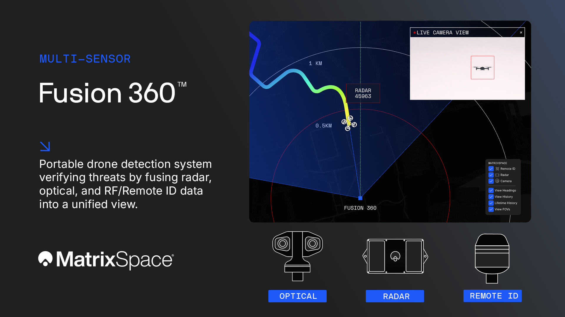
MatrixSpace Expands Portable Airspace Awareness Offerings with Fusion 360
Portable, Multi-Sensor Detection for Real Drone Threats
Burlington, MA (February 12, 2026) – MatrixSpace extends its advanced, portable drone detection portfolio with the launch of the multi-sensor MatrixSpace Fusion 360, verifying threats by fusing radar, optical, and RF/Remote ID sensor data into a unified view.
Fusion 360 delivers trusted counter-drone awareness by fusing radar, optical, and RF/Remote ID sensors into a single, authoritative airspace picture—so operators can confirm threats quickly and act with confidence.
Built as a fusion-native system, Fusion 360 correlates sensor data at the point of detection and tracking, reducing false alarms while improving identification of small, low-flying, and evasive drones in complex environments such as public events, critical infrastructure, and operational theaters.
It also distinguishes hostile “dark drones” from compliant or friendly aircraft, providing clear threat relevance instead of noise. The result: faster decisions, fewer distractions, and better protection.
Fusion 360 is the most affordable layered counter drone detection, tracking, and identification solution available today.
Quote from Matt Kling, VP and General Manager, AI Systems, MatrixSpace
“We take a radar and AI-first approach to low airspace awareness, resulting in a much higher quality output for users. Fusion 360 replaces a typically siloed approach, which is costly and misses critical drone activities. Our customers require a fail-safe, flexible, affordable solution, without wasting time on false threats.”
Why Fusion 360
- Verified threats, not guesses – Confirms whether a target is a drone and whether it is compliant, cooperative, or hostile.
- Detects dark drones – Identifies drones with no Remote ID or RF signature.
- Radar-first reliability – Maintains tracks in cluttered, GPS-denied, or RF-contested environments.
- Portable and scalable – Rapidly deploy, relocate, or network systems as coverage needs change.
- Shared situational awareness – Field operators and command centers see the same threats in real time.
- Open and interoperable – Integrates easily into existing C-UAS and security systems.
Powered by the MatrixSpace AI Platform, Fusion 360 synthesizes sensor data at the edge and applies context—behavior, compliance, and airspace rules—to determine what actually matters. The system is AI-native, making threat information immediately actionable.
Product options:
MatrixSpace Fusion 360 – Multi-sensor, layered detection and identification for high-risk environments. Built for those who need reliable, affordable, and deployable counter-drone detection—without false alarms or blind spots.
MatrixSpace Portable 360 – For those who require radar-only low airspace awareness across a range of aircraft and applications.
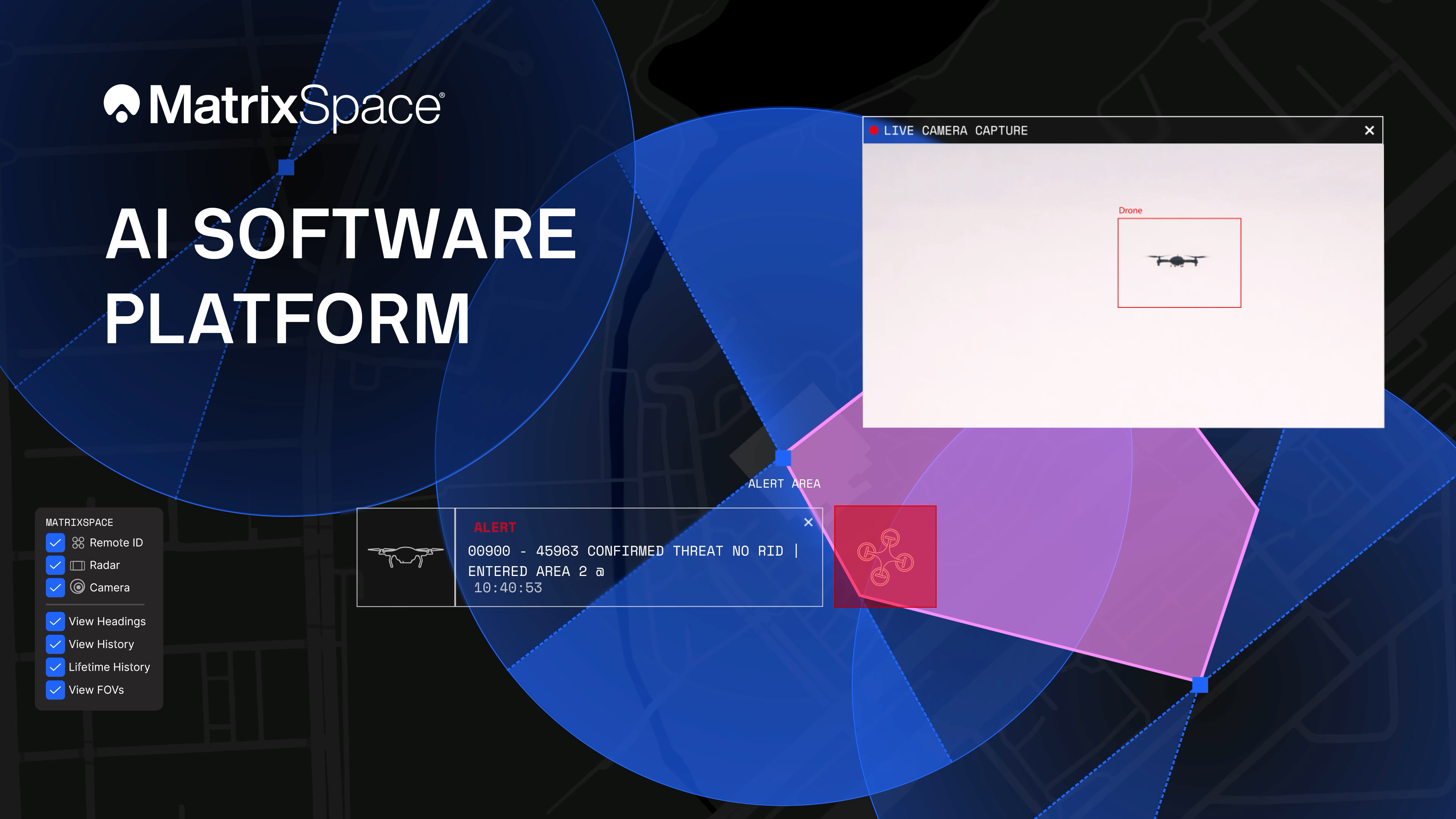
Announcing the Multi-Sensor Edge-to-Cloud MatrixSpace AI Software Platform
Burlington, MA (February 4, 2026) – Building on its award-winning portable AI-sensing radar for counter UAS, MatrixSpace announces a major update to its edge-to-cloud MatrixSpace AI Software Platform.
The platform now supports multi-sensor, multi-drone detection in real time for counter UAS applications. It delivers true threat assessment and early warning – detecting, tracking and identifying – to empower on-site and remote operators to make split-second decisions regarding airspace activity. The platform is sensor agnostic and easily integrated into existing systems through open APIs.
This dramatically improves assessing risk from small, low-flying drones in complex airspace, such as public events, critical infrastructure, and battlespaces.
The MatrixSpace AI Platform consists of MatrixSpace AiEdge, the company’s intelligent sensor operating system, and MatrixSpace AiCloud, a software-as-a-service that collects data from AiEdge-enabled sensors for a unified view of airspace activity. Unlike other offerings retrofitted for AI, MatrixSpace AiEdge and AiCloud are AI-native, making information rapidly actionable and easier to comprehend.
“Most traditional systems rely on noisy, exotic sensors with siloed, cumbersome command and control (C2) structures that hinder decisive action. But as threats of drone detection get only more complex, they require instant “threat truth”. Using AI to corroborate multiple inputs into one clear signal is the beauty of the MatrixSpace AI Software Platform, empowering customers to fully meet the threats we’re seeing today and in the future.” Matt Kling, VP and General Manager, AI Systems, MatrixSpace
MatrixSpace AiEdge, embedded in every MatrixSpace system, provides actionable intelligence at the point of sensor data collection. It detects, classifies and tracks multiple object types, removing “clutter” to present a relevant picture of aerial activities, while fusing feeds from different sensors.
AiEdge fuses detections from MatrixSpace radars with complementary sensors such as Remote ID and ADS-B into a single, real-time track. By correlating multi-sensor data at the edge, AiEdge creates a common data representation and cues PTZ (pan-tilt-zoom) cameras for rapid visual confirmation, passing high-confidence tracks to the cloud for enterprise-level analysis.
Sitting above distributed AiEdge deployments, MatrixSpace AiCloud simplifies the management of geographically diverse sensor networks into a single, unified view. Instead of a bank of monitors displaying individual sensor feeds, AiCloud provides operators with clear visibility into low-airspace activity, alerts, and warnings across all protected sites—accessible on any device.
MatrixSpace AiCloud combines fused, real-time data from radar, optical, ADS-B, and Remote ID sensors to deliver consistent object tracking and actionable threat intelligence at scale. Within AiCloud, whitelisting and threat classification determine whether objects are friendly, unknown, or hostile, enabling fast, coordinated operator response. Local sensors continue operating autonomously when cloud connectivity is disrupted, with all activity synchronized for review once connectivity is restored.

DIU, JIATF-401, USNORTHCOM, US ARMY Announce MatrixSpace Winner of C-UAS Low-Cost Sensing Challenge
Washington, D.C., (December 12, 2025) — Defense Innovation Unit (DIU), in close collaboration with U.S. Northern Command (USNORTHCOM), Joint Interagency Task Force 401 (JIATF-401), U.S. Army, U.S. Navy, U.S. Marine Corps, and U.S. Indo-Pacific Command, announced top-performing solutions for the Counter-small Unmanned Aircraft System (C-sUAS) Low-Cost Sensing (LCS) challenge. MatrixSpace Inc. has been selected as the overall winner and will receive the top award of $500k. In addition, the top three performers following the overall winner will each receive award amounts of $100k in recognition of their performance: Guardian RF, Hidden Level, Inc., and Teledyne FLIR Defense.
The selected systems secured a place among the 10 finalists who advanced to live testing during USNORTHCOM's Falcon Peak 25.2 exercise, outperforming 115 submissions. The system demonstrated capability in detection, classification, localization, scalability, cost, and integration readiness.
“Small UAS threats are evolving faster than traditional acquisition cycles, and meeting that challenge requires capabilities that can be deployed at speed and scale. The selected solutions show how commercial innovation can strengthen our layered defense - delivering affordable sensing that we can field widely, adapt quickly, and keep the warfighter ahead of the threat,” said David Payne, Acting Director of DIU’s Autonomy Portfolio.
“Building on our recent selection for Army xTech and Operation Flytrap 4.5, we are proud to be selected as the top performer and winner as a part of this DIU-led effort with an elite group of service branches to showcase how ultra-portable, AI-enabled, and cloud-connected CUAS solutions are redefining force protection for today’s defenders,” said Matthew Kling, VP and GM, AI Products at MatrixSpace.
"Our platform combines ultra-low SWaP-C radar, AI-driven edge intelligence, and distributed, networked CUAS detection powered by AiCloud to deliver unmatched performance in the field. During the evaluation, we successfully detected, tracked, and classified every sortie flown—including RF-dark fiber FPVs, commercial drones, and custom-built UAVs—demonstrating that portable systems can deliver mission-critical capability without compromise.”
A Scalable, Distributed Approach to Counter-UAS Sensing
The LCS challenge, launched in May 2025, was designed to complement exquisite sensor systems by identifying emerging technologies that enable broad, distributed, and resilient sensing architectures. During FP 25.2, the ten selected finalists demonstrated solutions spanning radio frequency passive detection, active radar, acoustic sensing, optical and infrared modalities, and hybrid systems. These technologies collectively showed potential cost savings of 50–80 percent in total cost of ownership, while still meeting key coverage and performance requirements for C-sUAS defense. During live testing, vendors were evaluated against a variety of small UAS flown both individually and in coordinated multiples, employing diverse communication protocols. Finalists were not informed which platforms or profiles they would be tested against, ensuring performance was measured under realistic, un-scripted, and operationally relevant conditions.
Evaluated by experts and end-users, against a rigorous selection criteria, challenge winners differentiated themselves by demonstrating tailored technical strengths, high performance against threat-representative UAS targets and demonstrating a cost-effective architecture enabling deployment at scale across fixed, mobile, and austere environments.
Pathway to Transition
As the top-performing solutions, the selected winners will share the LCS challenge prize pool of $800,000 and will be eligible for potential follow-on opportunities, including Other Transaction (OT) agreements, and other contract types, in order to expedite direct transition into operational use.
“JIATF 401 [Joint Interagency Task Force 401] has one measure of effectiveness: quickly deliver state-of-the-art C-UAS capability to the warfighter at home and abroad,” said Brig. Gen. Matt Ross "Our partnership with DIU contributes to warfighter lethality and homeland defense.”
About the LCS Challenge
The Counter-sUAS Low-Cost Sensing (LCS) challenge sought to identify emerging sensor solutions that could:
• expand detection coverage,
• reduce total lifecycle cost,
• integrate seamlessly into joint C2 architectures, and
• provide the resilience and redundancy required to counter small UAS threats.
Launched in May 2025, the challenge drew participation from traditional and nontraditional vendors across the country, representing the full spectrum of sensing modalities. The Falcon Peak 25.2 exercise provided a realistic environment to evaluate these capabilities under operationally relevant conditions.
For more information about DIU’s work accelerating commercial technology into the Department of Defense, visit www.diu.mil.
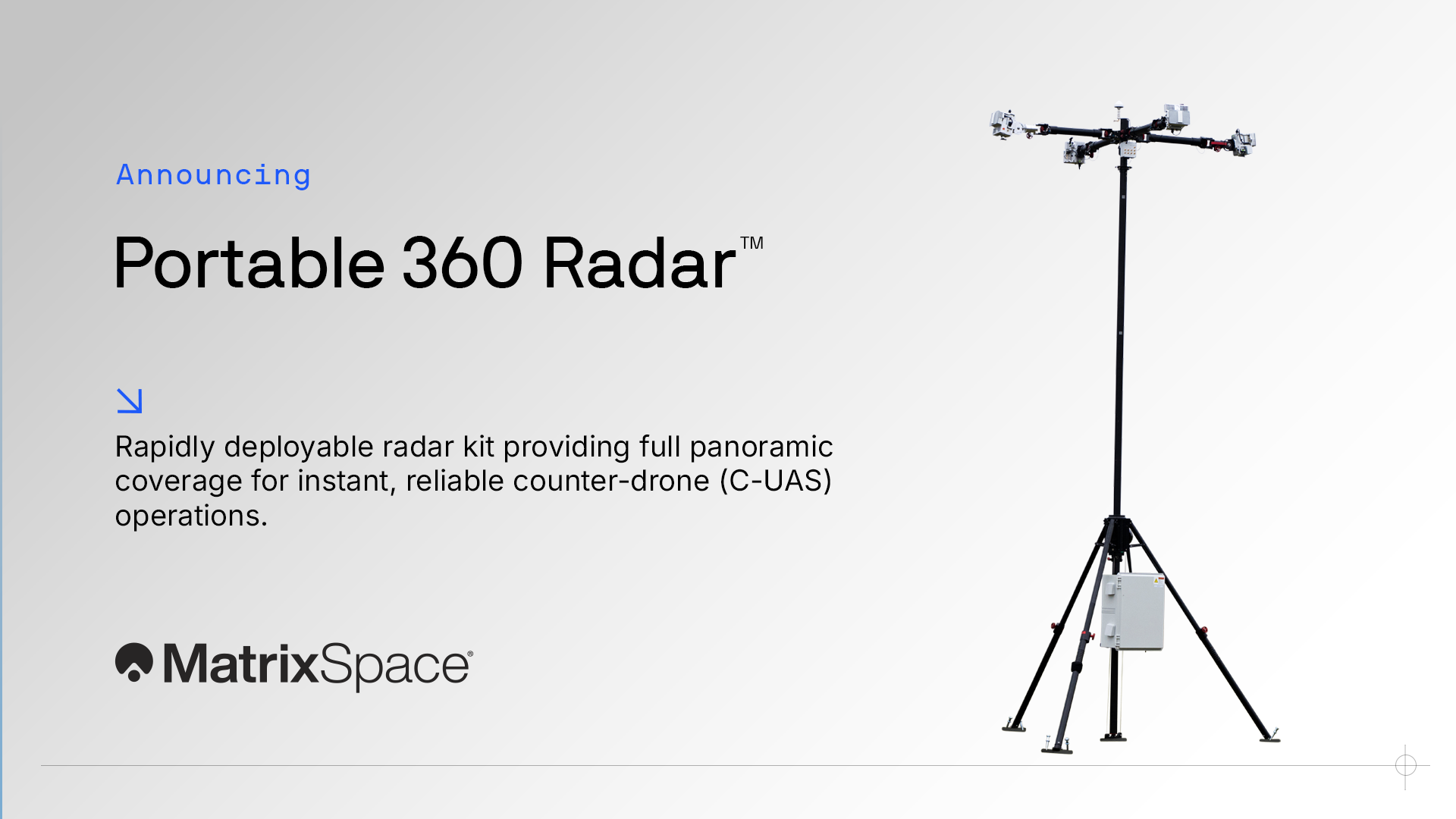
MatrixSpace Launches Portable 360 Radar™ for Rapid, Resilient Counter-Drone Operations Anywhere
MatrixSpace, a leader in portable AI-enabled radar for counter-UAS (C-UAS), announces the availability of its revolutionary Portable 360 Radar™.
This rugged, easily transportable radar kit delivers reliable close-airspace awareness with panoramic coverage for rapid-response counter-drone operations, from safe-guarding stadiums and large public gatherings, to border security and battlespaces.
Traditional radar systems are cumbersome, slow to set up and limited in effectiveness for mobile C-UAS deployments, with high-power requirements. Instead, MatrixSpace Portable 360 Radar is the industry’s lowest power, most portable and affordable low-airspace drone detection system available.
Unlike other available solutions, the MatrixSpace platform unifies threat awareness across multiple networked Portable 360 Radar systems and other sensors, without compromising local operation. By combining AI edge processing with MatrixSpace AiCloud Enterprise Software, central/remote command centers get an enhanced common operating picture and deep airspace activity analytics to assure public safety.
Major corporations and government agencies have already adopted MatrixSpace Portable 360 Radar, which has excelled in rigorous C-UAS field testing including the U.S. Army’s recent xTechCounter Strike competition where it won best active sensor.
“We’ve already seen the tactical advantage MatrixSpace Portable 360 Radar offers, in some of the most challenging situations possible,” explains Matthew Kling, VP & GM, AI Systems at MatrixSpace. “The demand for fast, easy setup of such capable systems is clear, as a wide range of organizations grapple with the reality of critical counter drone solutions.”
Key Features and Benefits
• Low power, small footprint—a portable radar system easily transported by car that assembles in minutes.
• Breakthrough affordability, enabling operators to catch hard-to-detect drones in challenging environments like dense cities and variable terrain.
• Resilient AI edge-first architecture powered by sophisticated AI edge processing that continuously improves, assuring decisive operations even in congested environments.
• Easy extensibility to MatrixSpace AiCloud — users can deploy one system or one hundred, all working together for enterprise command and control.
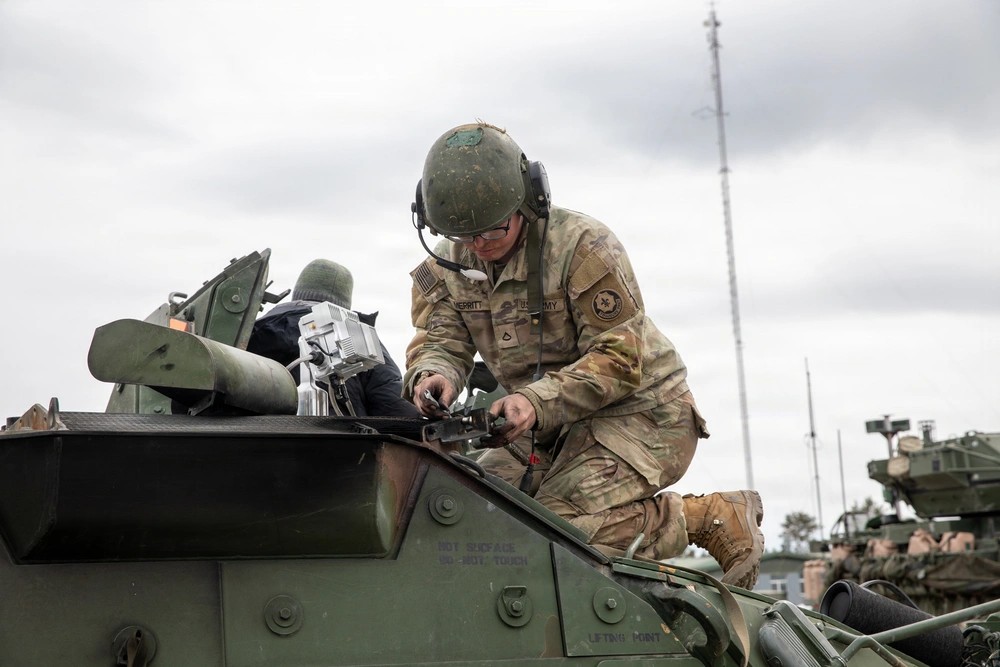
MatrixSpace Named Active Sensor Winner in U.S. Army Operation Flytrap 4.5, xTechCounter Strike Competition
Burlington, MA (November 24, 2025) – MatrixSpace, a leader in portable AI-enabled radar for counter-UAS missions, is the winner in the U.S. Army’s xTechCounter Strike competition, part of Operation Flytrap 4.5. MatrixSpace was the only active sensing provider selected among 15 finalists, highlighting the company’s breakthrough capabilities in rapidly deployable airspace awareness.
Operation Flytrap is the U.S. Army’s key initiative to accelerate innovative, scalable C-UAS technologies through live soldier experimentation, rapid acquisition pathways, and transition to operational units.
MatrixSpace showcased its Expeditionary AI Radar and 360 AI Radar, powered by AiEdge software, demonstrating fast setup, seamless integration into Army FAAD-C2 via the NATO-standard SAPIENT protocol, and real-time situational awareness at the tactical edge.
Four companies were selected overall, each receiving a $350,000 award and placement into the new Global Tactical Edge Acquisition Directorate (G-TEAD) Marketplace, enabling streamlined procurement by U.S. and NATO partners.
“Operation Flytrap 4.5 gave us a powerful opportunity to show MatrixSpace’s tactical advantage,” explained Matthew Kling, VP & GM, AI Systems at MatrixSpace. “Our ultra-low SWaP-C radars with AiEdge software integrate effortlessly into existing Army C2 networks and deliver dependable, soldier-ready airspace security.”
MatrixSpace radar systems deliver affordable, all-weather, AI-powered detection and classification for airspace, perimeter, and object monitoring, enabling organizations to rapidly establish robust situational awareness in contested environments.
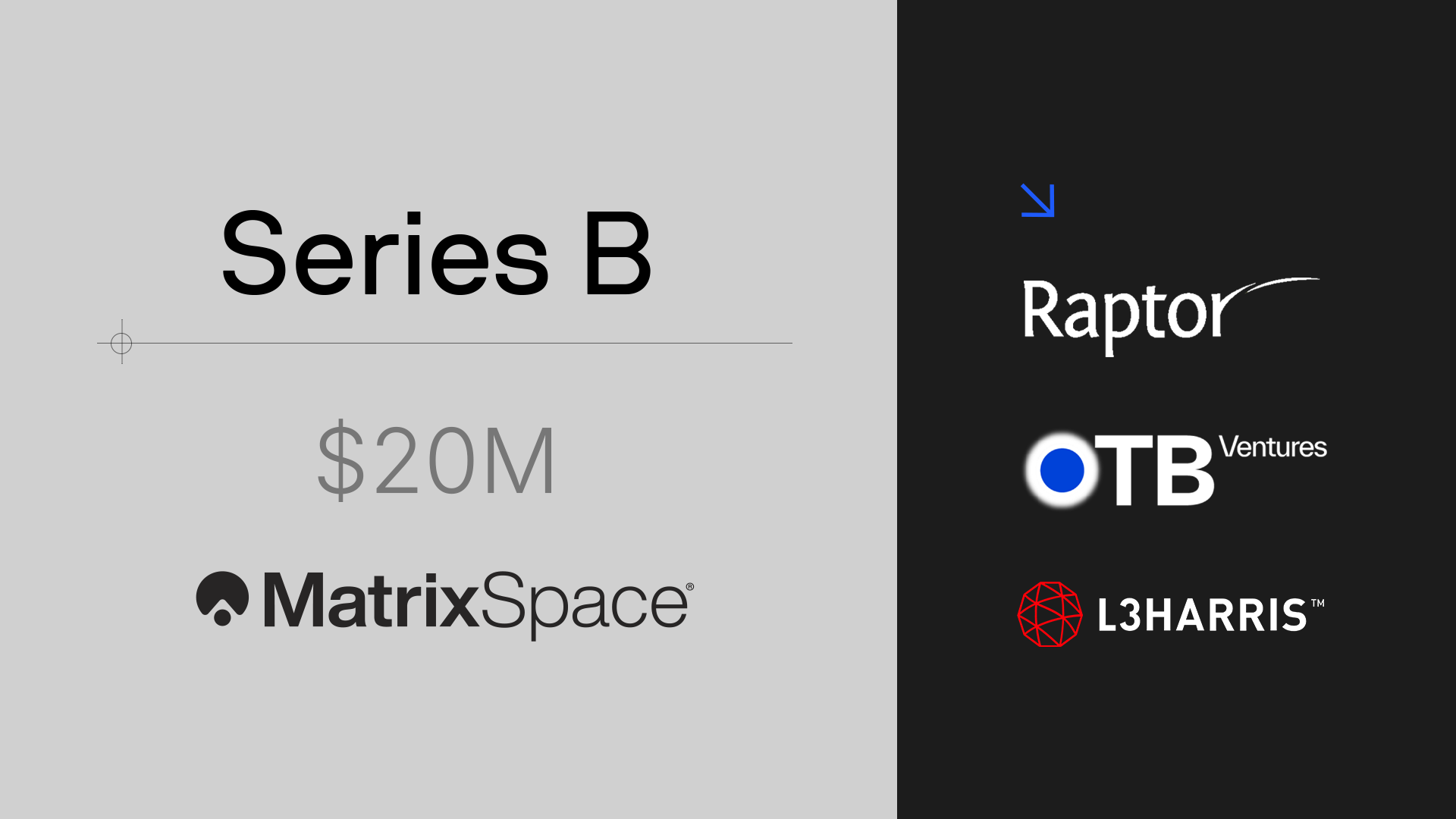
MatrixSpace completes $20M Series B Funding
Portable, AI-enhanced Radar Products for Counter UAS
Burlington, MA (October 15, 2025) - MatrixSpace, a leader in portable AI-enhanced radar counter drone sensing technology, announces the completion of its $20 million Series B funding round. This raise represents a significant valuation increase over the Series A of May 2023 and brings MatrixSpace’s total funding to date to $58 million. The completion of this round also introduces meaningful new investors, including L3Harris, to the MatrixSpace team.
The round was co-led by The Raptor Group and OTB Ventures. The Raptor Group is a Boston-based venture and growth fund investing in deep technology across a variety of industries. OTB Ventures is a leading European investor focused on dual-use defense and enterprise technology, with deep ties to both European industry and NATO.
“We’re proud to welcome new investors OTB Ventures and industry powerhouse L3 Harris to MatrixSpace, along with the robust engagement of our existing investors. This new capital and industry partnerships position us extremely well for our next chapter of growth and cements our leadership in portable CUAS, or counter drone systems,” comments Gregory Waters, co-founder and CEO of MatrixSpace.
"By combining advanced radar and AI at the edge, MatrixSpace sets a new standard for edge sensing, redefining situational awareness for both civil and defense applications. We’re proud to back the team shaping how autonomous systems will perceive the world,” comments Marcin Hejka, the co-founder and General Partner of OTB Ventures.
MatrixSpace Radar delivers affordable, AI-powered situational awareness in all conditions, including low-light and low-visibility. With leadership AI Edge and Cloud software for real-time classification, history, and predication capabilities organizations can create safe airspace rapidly and robustly.

Volatus Aerospace Secures Approval from Transport Canada to Launch Scalable Automated Drone Services in Canada
TORONTO, Sept. 03, 2025 - Volatus Aerospace Inc. (TSXV: FLT, OTCQB: TAKOF, FSE: ABB.F) (“ Volatus ” or “ the Company ”), a leader in aerial solutions, today announced that Transport Canada has issued a Special Flight Operations Certificate (SFOC) authorizing Volatus to conduct more complex Beyond Visual Line of Sight (BVLOS) operations by authorizing the use of MatrixSpace’s next-generation radar, integrated through Kongsberg Geospatial’s IRIS Terminal platform.
Unlike traditional ground-based radar systems, MatrixSpace’s technology is compact, low-power, and able to detect smaller non-cooperative traffic such as other drones. When integrated with Kongsberg’s proven airspace awareness and traffic management software, and supported by Volatus’ remote Operations Control Center, these capabilities make it practical to scale BVLOS operations into applications such as automated drone-in-a-box networks, distributed wide-area monitoring, and autonomous services where continuous, reliable detect-and-avoid is critical.
The global drone-in-a-box market was valued at just over US$1 billion in 2024 and is forecast to grow to between US$5 and US$9 billion by the early 2030s, reflecting annual growth rates of ~20–23%. 1 This rapid expansion underscores the commercial potential for scalable, subscription-based drone services such as those enabled by this new approval.
Volatus already holds nationwide SFOCs permitting BVLOS operations in low-risk airspace, atypical airspace, high altitude, and nighttime missions at an advanced regulatory risk level recognized by Transport Canada. Building on this foundation, the integration will expand automated drone-in-a-box services for infrastructure security, utilities, and industrial monitoring, as well as wide-area inspection and surveillance at higher altitudes, such as forestry, wildfire monitoring, and environmental oversight.
“This SFOC builds upon milestones such as Volatus’ approved BVLOS medical delivery operations at Halton Healthcare,” began Glen Lynch, CEO of Volatus Aerospace. “With our partners, we are expanding these capabilities by integrating a lightweight and scalable detect and avoid system. This combination makes it practical to move from specialized projects into wide-scale deployments like drone-in-a-box networks, giving customers safe, reliable, and scalable autonomous services.”
“We’re pleased to support Volatus with our IRIS Terminal platform as they expand advanced BVLOS operations,” said Jordan Freed, President and Managing Director, Kongsberg Geospatial. “By integrating real-time airspace awareness into their Operations Control Center, Volatus is demonstrating how safe and scalable drone services can be delivered for commercial customers.”
“This approval represents a major step toward scalable autonomous drone operations,” said Greg Waters, Co-founder & CEO, MatrixSpace. “Our compact radar technology is designed for exactly these kinds of applications, and Volatus is leading the way in bringing drone-in-a-box and automated services to the Canadian market.”
About Volatus’ Strategic Partnerships
Kongsberg Geospatial and MatrixSpace are two industry leaders whose technologies are helping to transform advanced BVLOS capability into scalable, commercially viable services. By combining Volatus’ operational expertise with Kongsberg’s airspace management software and MatrixSpace’s next-generation radar, the partnership creates a deployable ecosystem designed for safe and repeatable drone-in-a-box and autonomous operations.
Kongsberg Geospatial provides the IRIS Terminal platform, which integrates radar, telemetry, and other sensor feeds into a single real-time airspace awareness display for safe BVLOS operations. Beyond the technology, Kongsberg brings decades of defense and aerospace experience, opening access to global security and government markets where regulatory trust and mission assurance are critical.
MatrixSpace delivers the next step forward in detect-and-avoid: a compact, low-power radar system that is smaller, more flexible, and lower cost than traditional installations. It can also detect smaller, non-cooperative traffic such as other drones — making it ideally suited for scalable, autonomous deployments like drone-in-a-box networks. MatrixSpace’s growing presence in homeland security and critical infrastructure monitoring creates new opportunities for Volatus to expand into high-value markets.
Together, these partnerships enable Volatus to act as the integrator of a proven ecosystem combining operational expertise with advanced airspace awareness and next-generation radar to deliver safe, scalable, and commercially viable drone services.
About Volatus Aerospace
With 100+ years of combined aviation expertise, Volatus Aerospace delivers innovative global aerial solutions for intelligence and cargo, utilizing both piloted and remotely piloted aircraft (RPAS/drones). Committed to efficiency, safety, and sustainability, Volatus offers a complete ecosystem of aerial solutions including remote operations, enterprise equipment sales, training, and aerial services to enhance real-world applications across industries.

DroneSense and MatrixSpace Advance Beyond Visual Line of Sight Drone as First Responder Operations
Integration delivers AI-enabled radar situational awarenessto DroneSense Remote software,for scalable, real-time drone operations
Austin, TX – (July 10, 2025) – DroneSense and MatrixSpace have partnered to accelerate the safe expansion of beyond visual line of sight (BVLOS) drone operations for Drone as First Responder (DFR) programs.
The integration brings MatrixSpace Radar’s real-time object detection and airspace awareness capabilities directly into DroneSense Remote (DSR), the leading operational software platform for public safety drone missions. This enables radar tracking across urban and rural settings enhancing safety, responsiveness and mission success.
MatrixSpace Radar delivers affordable, AI-powered situational awareness in all conditions, including low-light and low-visibility environments. With AiEdge software for real-time classification and expandable centralized sensor fusion, agencies can scale DFR operations confidently.
Quote from Aydin Ghajar, Chief Operating Officer at DroneSense
“DroneSense is committed to building an open ecosystem that incorporates the best available drone hardware and detect-and-avoid (DAA) technologies. This integration with MatrixSpace represents the first of several partnerships to unlock BVLOS operations for public safety agencies. By bringing real-time radar awareness into our OpsHub interface, we’re enhancing both mission execution and safety.”

This capability has already supported some major milestones:
Palm Springs Police Department (PSPD) expanded its Drone as First Responder (DFR) program, establishing the largest first responder agency coverage area (37 square miles) monitored by radar sensors instead of humans in the United States.
Campbell Police Department (CPD) became the first law enforcement agency in California to receive FAA authorization for single-operator BVLOS missions under a Part 91.113(b) waiver using radar instead of human visual observers. The waiver enables safer and more effective drone operations, even during night or adverse weather conditions.
Quote from Chief Charles L. Werner (Emeritus-RET), Director of DRONERESPONDERS Public Safety Alliance
“The partnership between two exceptional technologies—DroneSense and MatrixSpace—is a game-changer. It delivers critical situational awareness to real-time crime centers, fusion centers, and command staff through a single mission platform.”
As more public agencies, regional consortiums, and critical infrastructure providers turn to drones for real-time intelligence, the integration of ground-based radar is essential to scaling safe and effective BVLOS operations.
Quote from Lori DeMatteis, Chief Revenue Officer at MatrixSpace
“DroneSense is leading the charge in advancing operational best practices and technology for public safety. Together, we’re delivering a turnkey radar and software solution that supports next-generation airspace awareness, including nighttime and low-visibility BVLOS operations.”
About DroneSense
DroneSense is the most comprehensive drone management and collaboration platform on the market—and the only software purpose-built for public safety agencies to fly, share, and manage their drone programs. DroneSense is on a mission to revolutionize emergency response through real-time situational awareness and operational coordination. Learn more at www.dronesense.com.

Sagetech Avionics and MatrixSpace Collaborate to Enable Advanced Detect and Avoid Solutions
Bingen, WA and Burlington, MA (May 20, 2025) – Aerospace technology provider Sagetech Avionics has selected AI sensing system innovator MatrixSpace to support its advanced airspace solutions. Sagetech Avionics empowers safe flight in crewed and uncrewed aircraft with certifiable situational awareness solutions, serving military, public and commercial organizations.
Both companies will be exhibiting at XPONENTIAL 2025 May 20-22, in Houston, Texas: Sagetech Avionics (booth #2031) and MatrixSpace (booth #1520).
MatrixSpace and Sagetech Avionics recently partnered to win an HSWERX award from the Department of Homeland Security (DHS) for their work on advanced air detection supporting uncrewed aircraft systems (UAS) operations. The solution has potential applications across a variety of mission environments, including the DHS Customs and Border Protection (CBP) agency.
Quote from Rudy Johnson, Director Business Development at Sagetech Avionics
"Our mission is to deliver low-SWaP certified avionics solutions that enable safe, scalable airspace integration. To achieve this requires a sophisticated level of airspace awareness informed by high-performance sensors. MatrixSpace is meeting the challenge, setting new standards in precision detection, making them key to meeting our customers’ demanding requirements.”
Quote from Lori DeMatteis, Chief Revenue Officer at MatrixSpace
“As autonomous aviation becomes ubiquitous, the need to integrate it safely into the National Airspace is key. Working with Sagetech Avionics has demonstrated their commitment not only to high customer standards but also reaching for the most advanced, innovative solutions possible to achieve this.”
The DHS project sought to identify small UAS (sUAS) with onboard sensors that meet Federal Aviation Administration guidelines for safe Beyond Visual Line of Sight (BVLOS) operations. Enabling smaller UAS (Group III and below) to operate safely in the NAS with BVLOS capabilities significantly enhances their ability to conduct comprehensive monitoring of secure, often large and remote locations such as borders, border crossings and other points of entry. Due to their compact size and advanced capabilities, MatrixSpace Radar and Sagetech’s detect and avoid (DAA) onboard ACAS DAA computer were selected to support safe BVLOS operations.
MatrixSpace provides affordable, AI-enhanced sensor solutions for situational awareness, unlocking advanced, large-scale drone operations, and protecting infrastructure and public gatherings from security threats. Its solutions detect objects immediately with high degrees of accuracy, allowing for rapid response and countermeasures. Its products combine cutting-edge radar sensors with additional technologies and AI-edge processing to sense, detect, and classify objects in any outdoor situation while enabling comprehensive compliance reporting.
MatrixSpace Delivers AI-Powered Edge Solutions for Public Safety and Smart City Applications
MatrixSpace integrates Dell NativeEdge to enhance real-time AI, strengthen public safety programs, and support next-generation smart city initiatives
Burlington, MA (May 15, 2025) – MatrixSpace, a leader in AI-enhanced radar sensing technology, announced that MatrixSpace 360 Radar is using Dell Technologies AI-powered edge computing to enhance its radar sensor solutions.
By integrating Dell NativeEdge, the advanced edge operations software solution that helps manage and secure technology deployed in the field, MatrixSpace is boosting the speed, security, and scalability of its situational awareness technology to support the future of public safety and smart city operations.
“Our vision at MatrixSpace has always centered on the edge,” said Dr. Nihar Nanda, Head of AI Products at MatrixSpace. “We needed a partner that could deliver the performance and reliability required for critical, real-time applications. Dell NativeEdge met those needs perfectly, allowing us to accelerate our AI development, enhance user experiences, and get these life-saving solutions into the field faster.”
The MatrixSpace 360 Radar combines a future-proof edge computing architecture with scalable AI software, delivering real-time object detection and classification, simplified system management, and accelerated decision-making without relying on cloud processing. Powered by Dell NativeEdge, each node provides a full 360-degree field of view with industry-leading detection range for aircraft and small drones and is interconnectable for consistent low airspace awareness across vast distances.
The City of Palm Springs Police Department (PSPD) is among the first to deploy this integrated solution. Through a network of MatrixSpace 360 Radars powered by Dell NativeEdge, the department supports its innovative “Drone as First Responder” (DFR) program. The system allows remotely piloted drones to be dispatched immediately to emergency scenes, helping to de-escalate incidents, locate suspects, assist in search and rescue missions, and act as a vital force multiplier for the agency.
Working with Dell Technologies, MatrixSpace is helping to lay the foundation for the next generation of public safety and security programs and the future of drone delivery and autonomous air mobility.
Visit MatrixSpace at Dell Technologies World (NativeEdge Pavillon), May 19–22 at the Venetian Conference Hotel in Las Vegas, NV, to learn more about how MatrixSpace and Dell are transforming the way our cities work and play.