Threat Truth or Dare: Layered Detection for Modern C-UAS
Addressing the evolving threats that small drones present to safety and security is top of mind now more than ever. Organizations are rapidly moving to evaluate and adopt tools that detect, track, identify, and defeat drones. While techniques to defeat drones vary widely based on jurisdictional restrictions, they all require sensing systems that can reliably detect, track, and identify drone threats. We speak with commercial, law enforcement and defense operators every day to learn what matters at the tactical edge for perimeter security and public safety. We also hear the concerns of their leadership within strategic command centers. What’s clear is that using one or two sensor modalities is no longer sufficiently reliable, and the concept of “layered” sensing has evolved. Effective multi-sensor systems now require radar as the backbone for detection and the ability to automatically assess threat levels in real time.
In the past, having two different modalities of sensors (e.g. optical cameras and radio frequency interceptors) may have been sufficient to detect and identify threats. Today, the rise of “dark” drones, remote ID counterfeiting and drone swarms now overwhelm this approach.
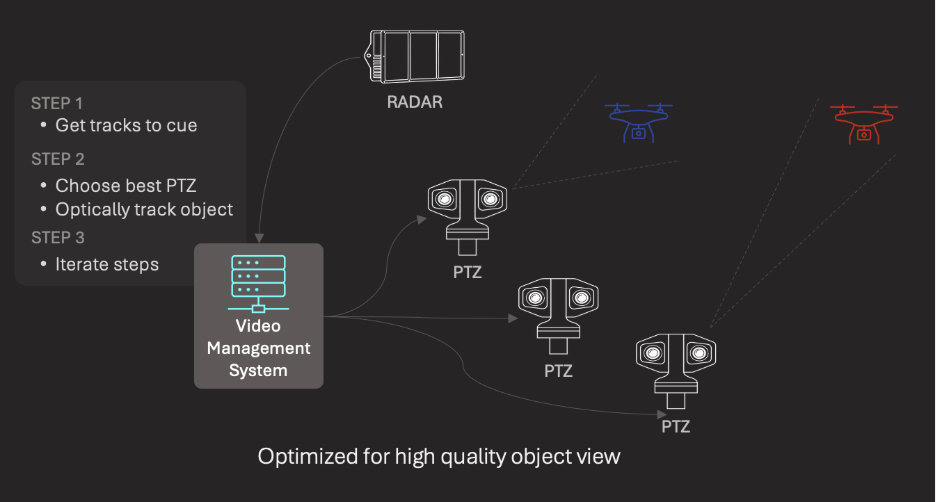
Moreover, most techniques that attempt to fuse multiple sensor inputs rely on the user to determine the nature of threats detected. Typical sensor “fusion” presents multiple concurrent inputs which need to be assembled and interpreted by the operator in either a video management system (VMS) or mission operations system. This manual assembly and assessment taxes an already highly burdened operator and often results in flawed assessments. Adversarial drones move fast and can carry deadly explosives, compressing the effective mitigation window. Manually assessing threat level delays mitigation decision-making, compromising safety and security.
Integrating radar sensors with optical cameras creates also significant issues. Small, fast, low-altitude drones are hard to keep in a camera's field view, especially at longer distances, even when cued by radar telemetry. This creates inconsistency and track loss. Radar nuisance tracks (clutter, birds, etc.) degrade reliability. Handing off positional cueing from radar to cameras for tracking purposes is limited by field of view, the number of cameras available, and repositioning delays.
A Different Approach
MatrixSpace is pioneering the use of AI to overcome these challenges. Artificial intelligence embedded at the edge transforms multiple sensor data feeds into a common format that allows for additional levels of assessment, including object recognition and bi-directional sensor control. It also facilitates further processing in the cloud against threat models resulting in actionable alarms and threat intelligence.
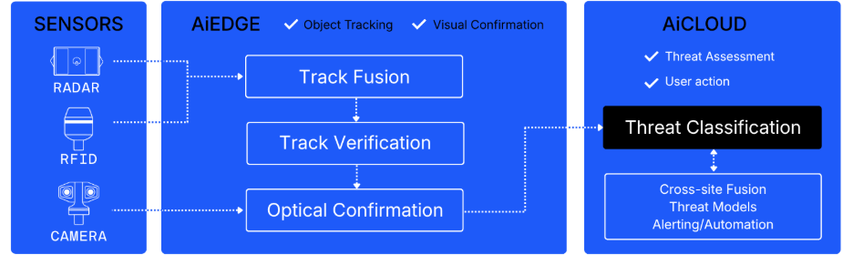
This model treats all sensors—radar, radio frequency/remote ID (RF) and optical—as a unified virtual sensor system to detect and track aerial threats. Combining radar and RF data improves track accuracy and enriches context for threat calculation. A PTZ camera feed confirms targets for visual validation and object classification. Fusing detections from sensors produces tracks with a richer set of metadata informing threat assessment.
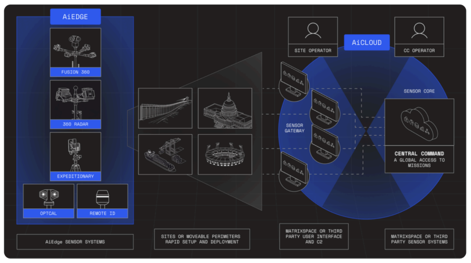
Multiple sensor fusion, false track reduction, and automated threat assessment are essential to secure the low airspace of urban areas. All this requires a unique edge-to-cloud data platform built for sensor fusion. MatrixSpace designed its AiEdge and AiCloud software based on exactly this architecture. Not only does the architecture provide resilient and scalable operations; it also supports the sensor-fusion requirements necessary to deliver comprehensive layered counter drone protection.
Radar: The Gold Standard
Radar has emerged as the backbone of modern C-UAS detection technology. Unlike passive RF-based detection technologies, radar detects all moving airborne objects based on their motion and reflectivity, not by whether they choose to emit signals.
Compared to RF intercept, which relies on detecting control links or telemetry, radar can still track drones flying on preloaded routes or using frequency-hopping/encrypted links. RF methods also struggle targeting objects in noisy or congested spectrum environments, while radar operates independently of command/control communications between drone and pilot.
Remote ID scanning is even more limited, as it depends entirely on compliance. Malicious or modified drones can disable or spoof Remote ID, making them invisible or misleading to those systems.
Radar is a reliable baseline that complements other sensing methods. It is also the most difficult modality to execute in a rugged, low power, highly portable form factor optimized for sensor fusion at low cost. This is why counter drone system manufactures “bolt on” 3rd party radar sensors, rather than building radar themselves. It’s also why these systems are extremely expensive and lack the depth of sensor fusion necessary to make C-UAS practical at scale.
Fusion 360
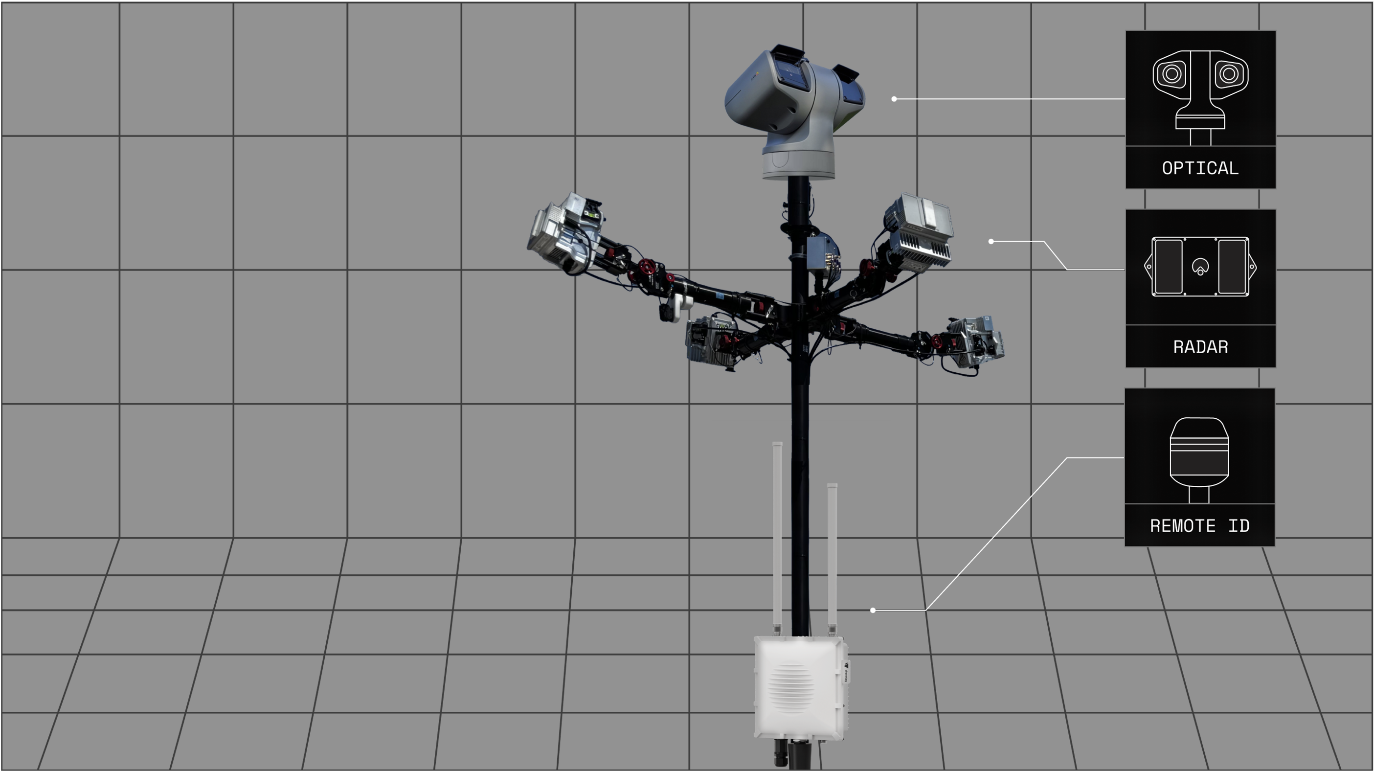
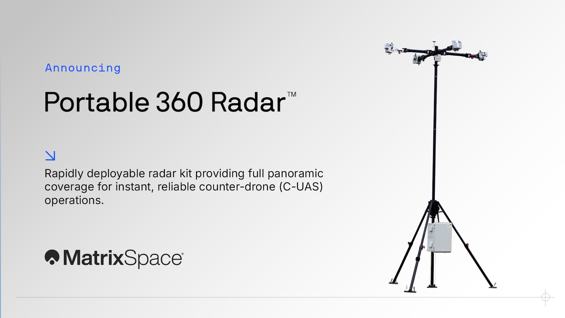
MatrixSpace Fusion 360 is the only radar-native, low-airspace, multi-sensor C-UAS detect, track and identify solution available today. Powered by MatrixSpace’s break-through ultra-low SWaP-C radar technology, Fusion 360 combines radar, remote ID and optical (PTZ camera) technologies to provide scalable threat intelligence at a price point previously considered unachievable.
The system correlates sensor data at the point of detection and tracking, reducing false alarms while improving identification of small, low-flying, and evasive drones in complex environments such as public events, critical infrastructure, and operational theaters. It also distinguishes hostile “dark drones” from compliant or friendly UAS, providing clear threat relevance instead of noise. The result: faster decisions, fewer distractions, and better protection.
Take Control of Your Airspace Security
Drone threats are real—and growing. Don’t wait until it’s too late. Contact our Solution Consultants today for a personalized airspace security assessment and discover how MatrixSpace Fusion 360™ can protect your operations anywhere, anytime.
👉 Schedule Your Assessment Now
Keep Reading
.jpeg)
MatrixSpace demonstrated portable, resilient counter-drone capabilities at the U.S. Army’s Flytrap 5.0 exercise, integrating mobile radar and AI systems with Anduril’s battle command network. The deployment validated effective small-drone detection, operation in contested environments, rapid dismounted deployment, and interoperability through open architectures for modern battlefield airspace awareness.
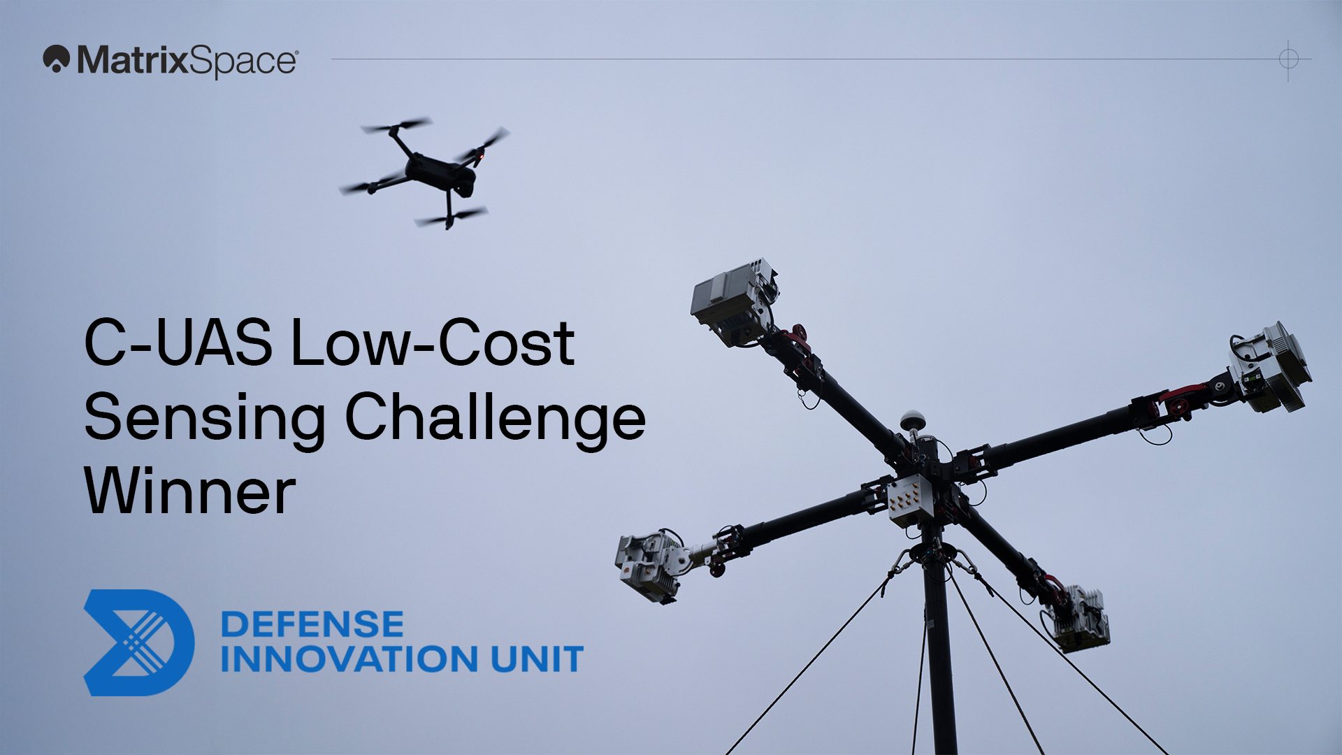
We're proud to have won both the DIU C-UAS Low-Cost Sensing challenge and the Army xTechCounter Strike competition. Innovation like ours is needed to modernize national security capabilities.
Protecting airspace security for temporary operations—whether stadium events, public gatherings, expeditionary maneuvers, or sensitive activities in/near secure sites—has never been more urgent. Drone threats are increasing, and traditional radar systems simply aren’t built for the speed and flexibility these scenarios demand.